|
Milwaukee to South Milwaukee.
The route follows the Milwaukee County Oak Leaf trail along the Milwaukee lake shore. From the Milwaukee Art museum, go south on Harbor Drive past the Summerfest grounds, west on Chicago, south on Milwaukee St, southwest across the Milwaukee River, southeast on Water St and east on Washington under the railroad bridge. Immediately after the railroad bridge, turn left, turn left (south) on the bike trail and follow it to its end. Turn left (southeast) on Kinnickinnic Ave to the junction with Bay St. Go east on Bay to its end at Russell Street. Turn left and follow Russell Street to its end.
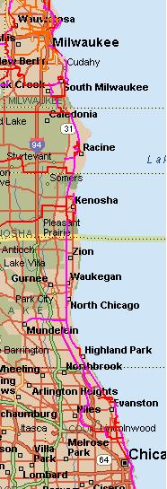
At the end of Russell St, pick up the scenic bike path that runs along Lake Michigan through a series of parks, ending at the Grant Park club house. This is the South Shore Line of Milwaukee County's Oak Leaf Trail (the red line on this map).
An alternative (or half of a loop trip) is to continue south on Kinnickinnic, which has separate bike lanes for much of its length. (For maps of bike trails and routes in Milwaukee city and county, click here.) When Kinnickinnic ends, go east on Layton and then south on Packard. At Oak in South Milwaukee, go east one block to pick up the Oak Leaf trail on the Oak Creek Parkway.
Jog south and then northwest on the Oak Leaf Parkway to the first cross street, Mill Rd . Go left (south) on Mill Rd. At the top of the hill, jog one block east to 5th and follow 5th to its end at Ryan Rd.
Oak Creek to Racine County
Between Ryan Rd and the Racine bike trails there are two possible one safer but longer than the other. The first avoids using the shoulders on highway 32, which can have quite busy traffic. The shoulders themselves can be disconcertingly narrow, particularly between 7-mile and 6-mile roads.
Here is the safer, but longer, route. It is particularly relevant when traffic is heavy on route 32. This route adds a bit under 4 miles but traffic is negligible:
- cross highway 32 and continue west on Ryan Rd.
- south on Pennsylvania Ave
- se on bike trail (a branch of the Oak Leaf Trail)
- e on County Line Rd
- s on Foley Rd
- continue s on E River Rd
- e on Five Mile Road
- s on Racine County bike trail
Here is the route that makes use of the highway 32 shoulders:
- Between Ryan Rd and Oakwood Rd: highway 32
- East on Oakwood Rd
- Between Oakwood Rd and 7 Mile Rd: bike trail (short jog on Elm Rd)
- West on 7 Mile Rd to highway 32
- South on highway 32
- East on 6 Mile Rd
- South on the unpaved Racine County bike trail (MRK Trail)
Taking this route north bound instead of south bound removes the need for two crossings of highway 32--at Oakwood and 7 Mile.
Northern Racine County
Follow the county MRK trail (crushed limestone surface) from Six or Five Mile Rd to its southern end at Layard Rd in Racine. Then follow the signs for the Root River Path.
An alternative all-paved route follows the poorly-marked Racine County bike route on local roads past the Wind Point Lighthouse. Turn left from Lighthouse Drive, to go south on Main Street until seeing bike path signs in about 1/4 mile to turn left (east) all the way to the lake to meet the Lake Michigan Pathway and connecting to the Lake Michigan Pathway.
Racine
Racine has two marked routes that connect the county trails north and south of the city. These combine bike paths and on-street routes.
- One route, the Lake Michigan Pathway, leaves the county MRK Trail at 3 Mile Rd and goes east on roads to the lake which it follows on paved bike paths to downtown. It then follows a marked route on city streets, joining the county trail near the southern edge of the city.
- The other, called the Root River Pathway, starts at the southern end of the county MRK trail and leads to the Root River, which it follows to Lake Michigan. A side route connects to the county trail. Except for a gravel section in Colonial Park, all bike paths on these routes are paved. Very good maps of this trail are posted on signs along the trail.
Information on both the Lake Michigan Pathway and the Root River Pathway is available here. However, the link to the map of the trails was inoperable as of this writing.
Racine to Kenosha
Between Racine and Kenosha, a paved county bike trail (sometimes called the MRK trail) runs along the route of the former North Shore Line between the outskirts of Racine and 35th St in Kenosha. Racine's Root River Path and Lake Michigan Path connect to this trail. To pick up Kenosha's Pike Trail, leave the county trail at Birch Rd and continue southeast to Carthage College.
Kenosha
Trail Link has a map of the Kenosha Pike Bike Trail that runs along Lake Michigan. The Pike trail is a mix of paved off-road trails and on-street routes.
At the north end, the Pike Trail diverges left from the county trail just south of 12th Street and uses a mix of streets and trails to get to the campus of Carthage College on the lake. From there a paved trail runs south along the lake to downtown Kenosha. South of downtown Kenosha, it uses a mix of streets and trails to get to 91st St where it turns west. It jogs north on 17th Ave to 89th St which it follows to the start of the county trail at the intersection of 30th Ave with 89th St.
Lake County, Illinois
From the Wisconsin border to Cook County, the bicycle trail is called the Robert McCrory trail. This trail is compacted limestone north of Great Lakes Naval station and paved to the south. Between Fort Sheridan and Highland Park the route follows streets but is well marked. The trail is picked up again at the south end of the Highland Park train station.
The Active Transportation Alliance sells a good map of the Chicago area that starts at the state line (but it also, in my experience, suffers from excessive optimism, showing bike paths that have been proposed but not yet built). Lake County also posts an on-line map of that county's trails.
An alternative in the southern portion of Lake County is the Skokie Valley Trail, a bit to the west of the McCrory trail. It runs from the North Shore Trail to Lake-Cook Rd. on the county line and can be used to make a loop trip.
Another trail through Lake County is the Des Plaines River Trail, an unpaved trail but in quite good condition. It follows the Des Plaines River through county parks and is scenic. The northern terminus is just south of the state line on Russell Rd, a bit east of I94. There is a short gap south of Half Day Rd of about a mile but it is possible to connect by riding on the shoulder of US 45. The trail continues in Cook County, but its condition deteriorates. Because this trail connects to Chicago's western suburbs, it could serve as an alternative route to Wisconsin for trips originating in those suburbs.
Connecting all three trails mentioned above is the North Shore Trail which runs east-west along Rockland Rd. (Highway 176). It is paved to the east of highway 41 and unpaved, in good condition, to the west. (Note that some guidebooks also call the McCrory trail the North Shore Trail.)
Cook County, Illinois
From the county line to Chicago, there are two good routes, mostly on trails. On entering Cook County, the McCrory Trail becomes the Green Bay Trail which extends south to Wilmette. The trail ends where Wilmette Rd crosses Green Bay Ave and the trail. Between this point and the start of the Chicago Lake Michigan trail there are a number of possible routes. Here is one:
- SE on Popular (parallel to Green Bay Rd, but low traffic)
- East on Lincoln Ave to the Northwestern University campus on Lake Michigan.
- South on Sheridan
- Where Sheridan turns east, keep straight on Chicago St
- Continue on Clark St
- East on Granville
- South on Winthrop
- East on Ardmore to the Lakeshore trail
The second route follows the North Branch Trail along the North Branch of the Chicago River through county forest preserves. At the Lake/Cook county line, go west on Lake-Cook Road (east, from the Skokie Valley Trail) to the entrance to the Chicago Botanical Gardens (Lake-Cook is busy and has no shoulder, so be careful). Enter the Garden and look for a service road that has a sign prohibiting cars. That is the start of the North Branch Trail.
At the southern end, leave the trail at Forest Glen Rd.
- South on Forest Glen
- Southeast on Elston Ave
- East on Lawrence to the lake shore trail
Chicago has a very good free bicycle map.
Southeast to Indiana
At the southern end of its lakeshore trail, Chicago has a marked route ontinuing southeast to the Chicago Skyway, where it picks up the Burnham Trail. A series of bike trails in northwestern Indiana can be used to cross into Michigan. The state of Michigan publishes regional bike maps.
If you have suggestions, please contact us.
Google ad:
|