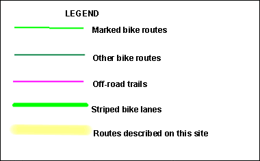
While most of our county maps are based on Wisconsin Department of Transportation county bicycle maps, the DOT map of Milwaukee County gives too little detail to be useful for bicyclists. Instead, a new map was created, using a Microsoft road map as a base. I have divided the county into three sections:
Milwaukee County North runs from the county line south to Hampton.
Milwaukee County Central runs from Hampton south to Lincoln.
Milwaukee County South extends south to Drexel.
 On this map, official city and county bike routes are marked in light green (see legend). There are usually signs along the routes, although these signs have a habit of disappearing.
Other routes that I suggest for bicycling are marked in dark green.
Off-road trails are marked in purple.
Streets with striped and marked bike lanes are marked with a broader green line.
If the road or trail is part of one of the routes described on this web site, a yellow marker is used.
Recently the Bike Federation of Wisconsin, in conjunction with Milwaukee city and county governments published a bike map of Milwaukee county. It is available for free at most area bike shops. It combines separate maps previously published by the county and city showing their respective systems and includes other suggested routes. Click here for information on this map and to download a draft version of the map (large file).