Wisconsin Bicycle Routes |
|||
|
Milwaukee County Bike Notes
|
|||
|
These are field notes prepared while scouting Milwaukee County as part of preparing a map of bike routes in southeastern Wisconsin. Public transportation: Bike racks are on all Milwaukee county buses. |
|||
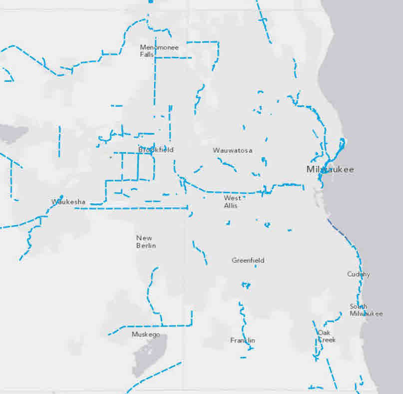
| I. Oak Leaf Trail. This is a combination of streets and parkways and paths. While it start A. The basic loop. The basic route started as the Milwaukee 64 and was renamed the Milwaukee 76 during the Bicentennial. The overall route has remained largely the same, although trails have replaced many on-road sections (including a rail-trail conversion from downtown to Estabrook Park) and the northwest section was rerouted from Grantosa and Good Hope to the Little Menomonee Parkway and Bradley Rd. Because of their age, some sections of bike trail are fairly rough. Recently constructed and rebuilt sections include the trail through Estabrook Park, parts of the lake front trail on the south side, a trail from Loomis to Drexel on the southwest side, and the trail between Capitol and Silver Spring on the Northwest. In addition to offering scenic rides, this loop connects to many of the other bike routes in Milwaukee County B. Inner extensions 1. Kinnickinic Parkway route. Mostly on streets and parkways on the south side 2. Lincoln Creek route. Branches off the loop in Estabrook Park and connects to a Milwaukee city bike route. Somewhat neglected: has the distinction of having the last uncut curbs that must be crossed. 3. Menomonee River extension to Doyne Park through Hart Park. Quite scenic. Connects by streets to the Hank Aaron Trail at Miller Park stadium. C. Outer extensions 1. Froemming Park extension. This trail goes south from Drexel between 51st and 68th streets, to the Milwaukee County Sports Center. It is possible to continue south on 60th Street into Racine County. 2. Southeast extension (not sure if there is an official name). This trail crosses Drexel a bit east of Howell. It follows a power line, then circles through a section of the Oak Creek Parkway to Nicholsen and Ryan Rd. South of Ryan road, it resumes following the power line to the Racine county line, passing under highway. It offers a good route to the Racine County trail. 3. Lake Park/Lincoln Drive trails. A system of trails runs along the lake front from the Art Museum north to Lake Park and south through Lake Shore State Park past the Summerfest grounds. On the lake side of Lincoln Drive, trails run the entire distance. On the bluff side of the drive, the trail runs north from the road to the marina. A new bridge connects the east trail with the rail trail (see below) and Brady Street. There are also trails on the top of the bluff. 4. East side rail line extension. From downtown at the lakefront to Estabrook Park, the Oak Leaf Trail follows a former Chicago and Northwestern rail road right of way. Rather than entering the park, this trail continues on the rail right of way most of the distance to Hampton, where it connects to Wilson Drive. Grants have been announced to connect this trail to the Borwon Deer trail using two different rights of way (see below). 5. Bug Line Trail Connection. A trail parallels Bradley to 124th where is goes south under highway 45. It is then possible to follow roads to the Bug Line trail and other routes in Menomonee Falls. 6. Brookfield Greenway trail connection. Connects proposed Brookfield trails to Oak Leaf Trail (see Waukesha county notes). II. Other Trails in Milwaukee County A. Franklin trail. An unpaved trail that runs south from Rawson to St. Martins. A branch connects to the Muskego Trail in Waukesha County. This forms part of the Milwaukee-Elkhorn route. B. Brown Deer trail. An paved trail that runs from the Ozaukee Interurban Trail south to Brown Deer Rd and the old Brown Deer business district. This forms part of one branch of the Milwaukee-Door county route. C. Milwaukee beer line trails. Several trails make use of the former train track that serviced the Schlitz and Pabst breweries. One goes along the side of the bluff between Brady Street and Humboldt, crossing the Milwaukee river on a “marsupial” bridge under the Holton Street bridge. Another starts at the end of Commerce Street, passes under the North Ave bridge, and then climbs up the bluff to end in Gordon Park at Locust Street. The third is a neighborhood trail that runs between Burleigh and Vienna in the Riverwest neighborhood. D. Hank Aaron State Trail. This trail runs between 6th St and 94th Place. East of 37th St it follows Canal St in the Menomonee valley. West of there it follows a former railroad right of way (there are only two grade crossings in this section). Eventually plans are to connect the Aaron trail with the Oak Leaf trail on the west side of Milwaukee. Currently the connection has to be made on streets. This trail is probably the fastest and best way to get from the west side of the county to downtown Milwaukee and Lake Michigan. It is part of the Winona-Milwaukee route. III. City of Milwaukee bike routes. In the last few years Milwaukee has developed a system of signed routes on low traffic streets. Since these routes are limited to the city, possible routes crossing political boundaries would not have been considered. Milwaukee is currently establishing bike lanes on a number of streets, both those on the official bike routes and others. Whenever possible, the map incorporates these. IV. Other routes. Milwaukee county offers a number of other routes that are good for biking. In some areas, there was a wealth of possible routes, so feasible routes were eliminated if nearby routes seemed better. In other areas, no route seemed desirable, particularly during rush hour. A. South side 1. North-south streets a. Lake front from Racine county to downtown (part of the Milwaukee-Chicago route). Much is on paths that are part of the Oak Leaf Trail and are very scenic. South Lake Drive runs parallel to the trail and is also used extensively by bicyclists. The section of highway 32 between Ryan Rd and the Racine county line is heavily travelled. The shoulders are well-paved but would be more comfortable if they were a bit wider. Particularly in rush periods, I prefer to go inland and use the southeast branch of the Oak Leaf Trail, but that route is longer. b. Packard to Kinnickinnic. This is an alternative to the Oak Leaf Trail. In Milwaukee, Kinnickinnic has bike lanes. c. 15th to Whitnall. These streets are wider and have less traffic than the Nicholson/Pennsylvania route. d. 6th Street. A reasonable route north from Grange to the 6th Street bridge over the Menomonee Valley. Moderate traffic; several sections have designated bike routes. e. 13th Street. This runs south into Racine county. South of Rawson to the county line, the route goes through sprawl, but traffic is much lower than on either 27th or Howell. f. 20th Street. From Rawson north, a Milwaukee bike route, Unfortunately, to continue south one must use Rawson to cross under the interestate and get to 13th St. g. 51st Street. Because it has several breaks, traffic on this route is quite low. The bicyclist must be careful making a left turn from Loomis at Edgerton or go through a parking lot to avoid riding on Loomis. Bicycle paths cross two of the breaks and one-way streets another. North of Kinnickinnic Parkway, the route uses small streets to connect to the winding lanes at the Wood veterans facility with its historic buildings, where it connects with the Hank Aaron trail. (I eliminated 60th Street because it has heavier traffic than either 51st or 68th.) h. 68th Street. This route runs from Greendale (quite interesting itself as one of the first three planned communities that were promoted by Eleonor Roosevelt) north through West Allis and into Milwaukee and Wauwatosa. Route moves to 71st Street before returning to 68th where there is a connection to the Hank Aaron trail. Perhaps because of the jogs, traffic volume is low throughout. i. 84th Street. A wide, moderate-volume street. The Oak Leaf Trail uses the northern part for its Kinnickinnic Parkway branch. It passes under the Hank Aaron trail but does not connect to it. For that, one must got west to 94th Place or east to 76th St. 84th also serves as a route connecting Milwaukee to the Seven Waters trail (see the Milwaukee-Elkhorn route). j. 92nd Street. A good route from Beloit Rd to Bluemound. South of Beloit, it becomes narrow. k. 116th Street. A very bicycle friendly route from the Oak Leaf Trail at Morgan south to Woods Rd. Traffic on county J can be heavy during rush hour with no shoulders, but this section is short. 2. Diagonals a. Loomis Rd is used by some bicyclists in a hurry who do not mind the cars and trucks whizzing by. It generally has sufficiently wide shoulders but is too busy for my taste. b. Forest Home. Traffic is fairly heavy, but in much of Milwaukee bike lanes have been added and sections are used for the Milwaukee bike routes. The quality of the shoulders at the intersection with I-894 is poor. c. Beloit Rd. Of the diagonal roads, this is much the nicest. It has moderate traffic and wide shoulders. It ends just before the intersection with National and Miller Park Way. It may be best to use sidewalks in this area. 3. East-west streets a. Oakwood. Mostly low traffic and largely rural. b. Puetz. It is generally okay, but busy near the intersection with Howell. c. Drexel. Used by the Oak Leaf Trail. Can continue west to the Franklin and Muskego Trails. d. Grange. Generally a good route across the county. e. Edgerton. Low traffic route, but ends at 13th. f. Cold Spring. With Bolivar, can cross the county. Generally low traffic. g. Morgan. Used by one of the Milwaukee city routes. Wide with low traffic. Much less traffic than nearby streets such as Oklahoma or Howard. h. Cleveland. From Beloit Rd west. Probably the best on-road route to Waukesha. i. Lincoln. Heavy, but slow, traffic. j. Greenfield. Heavy, but slow, traffic. At the Waukesha county line, its shoulders disappear, so this is not a recommended route into Waukesha County. k. Bruce Street. A series of streets just north of National Ave. from 1st Street to Miller Park. At 37th St there is a connection with the Hank Aaron trail. 4. Mitchell International Airport. a. To the airport. From the intersection of Grange and 6th (on a Milwaukee bike route), go south on 6th under the Airport Spur freeway. Go east on Air Cargo Way. Continue east across Howell and onto the airport access loop. b. From the airport. Take the one-way airport access loop west and follow signs for Howell Ave. Cross Howell onto Grange, and continue to the intersection with 6th. B. North side 1. North-south streets a. East side in Milwaukee. There are numerous routes, including paths along the lake and the Oak Leaf Trail along a former right of way. Bike lanes have been marked on Prospect (north-bound) and Farwell (south bound), Water St between Kilbourn and Brady, and Oakland between North Ave and the boundary with Shorewood. b. Lake Drive. This is a major commuting route that is also heavily used by bicyclists between Milwaukee and Bayside. Traffic can be heavy. c. Santa Monica Blvd. This is a low-traffic alternative to Lake Drive. It starts at the end of the railroad bike trail just south of Hampton and continues to Fairy Chasm Rd in Bayside. Between Fairy Chasm Rd and Zedler Rd in Mequon, bicyclists must take Port Washington Rd.. This has hazardous traffic, particularly at the exit from north-bound I-43 to Port Washington Rd. d. Holton Ave. This is a fairly wide, moderate traffic route from downtown to the area north of Capitol. Since Holton dead-ends north of Capitol, the route makes a series of jogs to pick up the Oak Leaf trail at Hampton. Alternatively, at Capitol one can go east across the Milwaukee River (bike lanes on the bridge) and then go north into Esatabrook Park. e. Milwaukee River route to Mequon. Take the Oak Leaf trail to Dean Rd. Turn north on Range Line. After crossing Brown Deer Rd go west to pick up the Upper River Rd and River Rd to Mequon Rd. This is a very scenic route along the east bank of the Milwaukee River. f. Oak Leaf to Interurban Trail connection (see Milwaukee-Door route). Take the Oak Leaf Trail north from downtown. Go west on Green Tree Rd and then north on Green Bay Rd (new surface with wide shoulders). Just after the junction with Teutonia, very carefully turn left onto Ruth and take Deerwood Rd north through the old Brown Deer business district. Take W River Lane west and cross Brown Deer Rd. Take a short stretch of sidewalk along Brown Deer to the WE Energies substation. This is the start of the Brown Deer Trail that runs north to connect with the Interurban Trail. g. N 20th. Continues the south-side route from Marquette University to Keefe Ave. h. Washington Park North. This route runs from Washington Park to Mill Rd. North of Washington Park, it takes the elegant Grant Boulevard and then switches to 37th. It uses Congress to go west to 47th which it follows to McGovern Park. It then uses Sherman Boulevard (heavy traffic) to Mill Rd, offering access to the Havenwoods State Forest. North of Mill Rd., Sherman becomes 43rd St and loses its shoulders. i. 60th. From Mill Rd north to Donges Bay Rd (and the Interurban Trail) in Mequon. j. 68th. Continues the route from the south side to Mill Rd. Between Lisbon Ave and Dineen Park, the bicyclist must detour either east or west around two large cemeteries. k. 88th. This route runs between Ludington Ave./Milwaukee St. in Wauwatosa and Grantosa Ave, entirely in residential neighborhoods. 2. Diagonals a. Lisbon. From Center to Capitol with connections to the Oak Leaf Trail. A wide boulevard with moderate traffic. b. Roosevelt. A nice boulevard that runs northeast. The route leaves Roosevelt just before either of its ends to avoid streets with heavy traffic. c. Grantosa. A nice wide attractive boulevard, formerly the route of the Oak Leaf Trail. 3. East-west streets a. Wisconsin Ave. This is a main bicycle commuting route from the west to downtown (and also a marked Milwaukee bike route from downtown to the bridge over the Menomonee River). West of that bridge, one can go north to Doyne Park and a branch of the Oak Leaf Trail. Continuing westward, Wisconsin ends at highway 100. I suggest two possible routes: (1) At 104th St, go south to pick up Bluemound or (2) Take the bike trail that leads north to the Milwaukee County Research Park, go west on Research Drive, cross highway 100 to Potter, and follow Potter until it joins the Oak Leaf Trail b. Blue Mound. After crossing the Menomonee River on Wisconsin Ave, the bicyclist can swing south and continue west on Blue Mound. The eastern part is a wide boulevard. Around Hawley are marked bike lanes. Continuing west, traffic becomes heavier, particularly around the intersection with US 45 and Highway 100, but there is a wide curb/parking lane. (In Brookfield signs restrict the right hand lane to buses and bicycles.) c. Highland Blvd. This is the best route for bicyclists from downtown to 37th St. West of 12th St, Highland is a boulevard with low traffic. To continue west from 37th, there are two routes: (1) Take 37th south to Wisconsin Ave. (2) Continue north on Highland to Washington Park. There are three alternatives from that point: (a) Continue north and pick up the Sherman Blvd route described in the previous section. (b) Go northwest through the park to Washington Blvd and the Washington Highlands. (c) Go west on Vliet, which becomes Milwaukee Ave., and eventually Ludington. One can either continue north on the 88th St route shown in the previous section or join the Oak Leaf Trail along the Menomonee River Parkway. d. Pleasant/Walnut/Lisbon/Lloyd. This route runs from the Milwaukee River to the Menomonee River Parkway in Wauwatosa. It is a marked Milwaukee bike route to 50th Street. At 73rd, it goes north to Watkins St, using a short section of sidewalk to connect dead-end streets. After passing the Wauwatosa Public Library, take the sidewalk on the south side of the street to reach Jackson Park Blvd. To continue to Brookfield, take North Avenue. (North Avenue is a direct route across the county. There are marked bike lanes east of Humboldt and apparently plans for additional bike lanes. Traffic is heavy, so I prefer either Center St. or the Pleasant St route described above.) e. Center St. Runs from Humboldt Ave to the Oak Leaf Trail near the Waukesha County line. Most of it has marked bike lanes. In addition to its bike lanes, the lack of an intersection with either I-43 or with US 45 tends to reduce traffic. At its western terminus, here are choices to continue west: (1) Go north to Burleigh and continue west on Burleigh into Brookfield. (2) Go south to North Ave. and: (a) Take North Ave. to Mayfair Mall. Take 104th St (the road bordering the eastern edge of Mayfair) north to Center and continue west on Center into Brookfield (very low traffic). (b) Continue west on North Ave. into Brookfield. f. Burleigh/Townsend/Keefe. This route crosses Milwaukee from Humboldt to 87th. g. Congress. This route follows Lincoln Creek including some short bike trail sections along the creek. h. Villard. A low-traffic commercial street. Villard ends shortly before Timmerman Airport. The route follows residential streets to Silver Spring Drive, with heavy traffic but fairly good shoulders. (East of here, Silver Spring is a route for the cyclist who doesn’t mind traffic. The shoulder/parking lane is generally good except for underpasses. Several sections have marked bike lanes.) i. Mill Rd. With Bender Rd, a route from Lake Michigan into Waukesha county, with moderate trattic. j. Bradley Rd. This is used by the Oak Leaf Trail. It is the most northerly east-west route. (Brown Deer Road to the north has heavy traffic in its six lanes and no shoulder or parking lane.) 4. The Northwest wasteland. North of Bradley Rd and west of 60th Street, there are no recommended routes. The north-south roads are busy, narrow, and in poor condition, with no shoulders. This situation may change if and when these roads are rebuilt. Note should be made of a couple of routes into the neighboring counties: a. Good Hope Rd into Menomonee Falls. A bike trail has been constructed in Menomonee Falls along Good Hope Rd from a point just west of highway 41 to Pilgrim Rd. It appears there are plans to connect this to the Oak Leaf Trail, but this has not been done yet and traffic on Good Hope in this area can be very heavy. The map shows a circuitous route from Mill Rd to the bike trail using frontage roads. b. Dretzka Park to Germantown. The map shows a route running from Bradley Rd, along Leon to Lilly and Fountain, Fond du Lac Ave, to Country Aire Dr., the boundary between Ozaukee and Washington counties. To cross from Lilly to Fountain requires using a road in an industrial park. Traffic on highway 145 seemed moderate when I looked at it, certainly far better than any of the roads to the east. |
|||